Monday 19 January 2009

Week of Monday 12 January 2009 - Yea - Sydney - Queensland


Monday 12 January 2009 – I had breakfast in a nice little park in Yea. It was very interesting as there was a large wetlands area with walking tracks (Darryl went to check it out while I ate), but also for the display on plant fossils in the area, and a footpath which was a geological timeline. 

We were heading up to Mt Buller, and stopped on the way at a little creek-side picnic area. The March flies were relentless, and I am sure we killed at least 30, but still they came! Darryl was thrilled to find plums and apples growing wild. Although the fruit was very small, it was sweet and juicy, and he picked all the ripe ones he could find. The Mt Buller alpine village amazed us, with huge apartment blocks (quite a few for sale), very expensive houses, and a lot of off-season maintenance and new work being carried out. We were able to walk to the 1805m summit, which had fantastic views, as well as a fire lookout station. Lake Buffalo was a busy spot with boaties and skiing. We were looking for a camp-spot and were quite disappointed that it wasn’t allowed, so ended up in a pretty, shady picnic area at Rose River.

Tuesday 13 January 2009 – I was hoping to go to the top of Mt Buffalo, but the entry fee just for a look was not worth it, so we had to just admire it from a distance. Over the next mountain range was an excellent lookout of the 1987m Mt Bogong. This was on the road up to the alpine village of Falls Creek, which was very uninteresting, especially made bleak by all the huge dead trees. They had been killed in fires some years ago, so many, in fact, that the dead black bark has fallen off, and what remains is silvery white 'skeletons'...it was very eerie. We turned around and headed back down the highway, stopping on the way for a short walk in to Fainter Falls – a pretty little diversion. Back down out of the highlands we started to experience the 40oC heatwave which was hitting Victoria, and after all the cold we had been experiencing, his was a big shock to the system. 
We made it as far as Gundagai NSW, and chose the riverside caravan park as far from the highway as we could get.


Wednesday 14 January 2009 – We were woken b y huge flocks of white corellas landing in the riverside trees.   We headed for Sydney, diverting to Fitzroy Falls National Park for lunch. This as a very commercialised, and busy, spot. We walked through the rainforest walk to the falls, which were not flowing well. Further on, the 'Twins Falls' were both completely dry. On returning to the car, though, we were thrilled to see a huge male Lyrebird scratching in the undergrowth. Although he did not display his tail he was just magnificent. I never thought that they were so big! Our trip into Sydney was by the 'scenic route' as we travelled through Canterbury and Bankstown. We crossed the very attractive Anzac Bridge and Sydney Harbour Bridge, eventually finding our way to meet Donald (a cousin on my Anderson side), and his wife Margaret. I had really been looking forward to this meeting for the 12 months or so since I had found him, and it was fantastic. Donald's resemblance to the Andersons on my side of the family, and their comments about my similarity to one of Donald's aunts made the whole thing fall into place. Donald had some wonderful stories and memorabilia from his branch, but the piece de resistance was a photo of our common ancestor, William Henry Anderson, taken in 1897! I had never seen a photo of him before, so this really made my day. This visit ended all too quickly, so I am looking forward to still catching up in the future we headed out of Sydney on the Pacific Highway, and made it to Darryl’s aunt (on the Walsh side) and uncle, Pat and Don at Lake Macquarie.

Thursday 15 January 2009 – It was lovely to have time to chat to Pat and Don, and Pat made m a really delicious breakfast and fresh fruit salad, and scrumptious scrambled eggs, while Darryl took the opportunity to kayak on Lake Macquarie. Then it was time to hit the highway, and we drove to Sawtell, a little holiday town just south of Coffs Harbour. The heat during the drive had been oppressive and relentless, so it was great to book into a green and shady caravan park. The reason we had opted for this lace (which I had previously never heard of) was that Darryl's cousin Mandy and her family were on holiday there. We had a lovely evening catching up on all the family news, and, once again, it was over far too quickly.

Friday 16 January 2009 – The caravan park was full of birds – we were woken by scrub turkeys running around, but there were also Yellow Tailed Black Cockatoos, Ibis, Magpies, Ducks, and native Pigeons. It as a shame to leave such a lovely setting, but we had another long drive ahead of us. 
At Tweed Heads I wanted to visit the crematorium to see the resting place of my maternal grandfather Victor Sidney Anderson. His ashes are scattered here and, as an ANZAC, he has a war graves plaque. A navigational misdirection given by me meant that we went down the main street of Coolangatta – not good for Darryl, but very interesting for me to see, all the changes as I hadn't been there since the mid-70's. 
It was then travel north and west and we ended up at Spicer's Gap National Park. We both felt a strange sense of relief to be back in Queensland – we talked about this and I think it is partly being back in familiar territory,  partly because we had been away so long, and partly because there is always a nagging feeling that elsewhere you might just be inadvertently be breaking some law or breaching some etiquette...


Saturday 17 January 2009 – An early start took us to the Fassifern Valley Lookout, through sub-tropical rainforest, and to views of the volcanic mountains of the area. Bare Rock was particularly striking, but I couldn't get a clear photo. A lot more driving north took us to Cordalba, to visit our friends Anna and Otto. On the way there were clearly storms building up in Goomeri, Ban Ban Springs and Biggenden, and soon after arrival in Cordalba there was plenty of lightening, thunder and heavy rain. It was a lovely evening spent cooling off with Anna and Otto in their immaculate pool, being serenaded by 100s of frogs.

Sunday 18 January 2009 – Darryl had to visit the farm as the new tenants had reported a leaking pipe, so he dropped me at Rhonda and Phil's. On his return we drove to Gladstone to see his parents, Eileen and George, and Kerry, Elizabeth and Anthea also called around to say hello. Anthea is doing really well, she was able to transfer herself from the wheelchair into the car, she recently walked 20m with crutches, and is swimming 30 laps a day! We arrived home around 7.30pm and saw Shane and Marc in the evening.

Woohoo! It is really nice to be home. There won't be any more posts for a while (please let me know if you want to be taken off the list, and apologies for the messages sometimes coming through more than once...I think it was to do with tardy internet connection..)
 

Monday 12 January 2009

Week of Monday 5 January 2009 - Mole Creek

Monday 5 January 2009 – From the visitor's centre there were a few short walks, 'The Enchanted  Walk', Pencil Pine Falls and Knyvet Falls, and the 'Rainforest Walk' – while all of these were interesting, they would be really exciting to someone new to the area, after our other walks they did not live up to our expectations.  A slow leak in one of our back tyres necessitated a trip to Devonport for a repair. This also gave us an opportunity to stock up on groceries. Our search for a park, in the city to have lunch, yielded a strange one with houses backing onto it, no toilets or water facilities, apart from a stagnant pond, and the howling wind meant that we ate as quickly as possible then headed back to the warmth of the car. 

Heading south to Lake Barrington, we found Devil's Gate Dam – a very interesting construction curved horizontally and vertically as well. Darryl then took me to Paradise, which didn't take long, but the district is quite scenic with rich red farming soils, and beautiful mountain backdrops. Back when we were in Hobart, I had received an email from one of my cousins, Donna (on the Smith side), to tell me that she and her husband, Michael, had shifted from Ipswich in Qld to Tasmania. They wanted to catch up and we headed for their new home near Mole Creek.
This is in the Meander Valley and is a really beautiful location. They have a few acres with a historic homestead, are surrounded by beautiful mountains, and have a lovely creek with brown trout and platypus. We had a very pleasant evening, catching up on family news, admiring all the work they have done in the few weeks they have been there (only since the end of November), and hearing their plans for the future.

Tuesday 6 January 2009 – Apart from poor Michael, who had to go to work at 5.30am, we all had quite a sleep-in, and a leisurely breakfast. Eventually we had packed up and drove into Mole Creek, where I got information on some of the local walks. While driving towards Marakoopa Caves, I noticed that my maps said the gorge beside us was called 'Sensation Gorge'. Darryl headed off to investigate, while I enjoyed a coffee, but he was soon back with the news that a short way downstream was an interesting dry creek, gorge, dry waterfalls, and pools, so I returned with him, and found it quite lovely (this is not mentioned anywhere as being a feature or walk). Fern Glade walk at the caves was supposed to be 20 mins, and may have been that, but it was a delightful walk, well described by its name, and we had lunch there at the picnic area. 
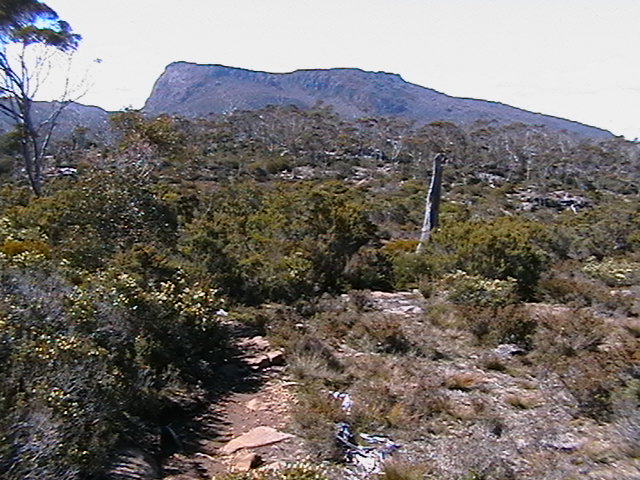
We the drove up to more that 1100m to Devil's Gullet which afforded spectacular views across to Cradle Mountain, and many others, and had wonderful dolerite columns, and a steel lookout perched on top of a sheer cliff up which the wind blew and howled. Next destination was past Lake Polanganga, and Lake Rowallan, where there had obviously been some sort of canoeing event (we later discovered this was the World Kayaking Championships..we think), and up to the base of 'The Walls of Jerusalem National Park'. At least a dozen vehicles were in the carpark, including a bus, and a taxi (with driver) waiting for two girls due back after 5 days, who were a bit overdue. So this as obviously a popular place, despite the lack op information from National Parks and Tourist Info on the area and walks. We found a spot at the end of the road to set up camp.


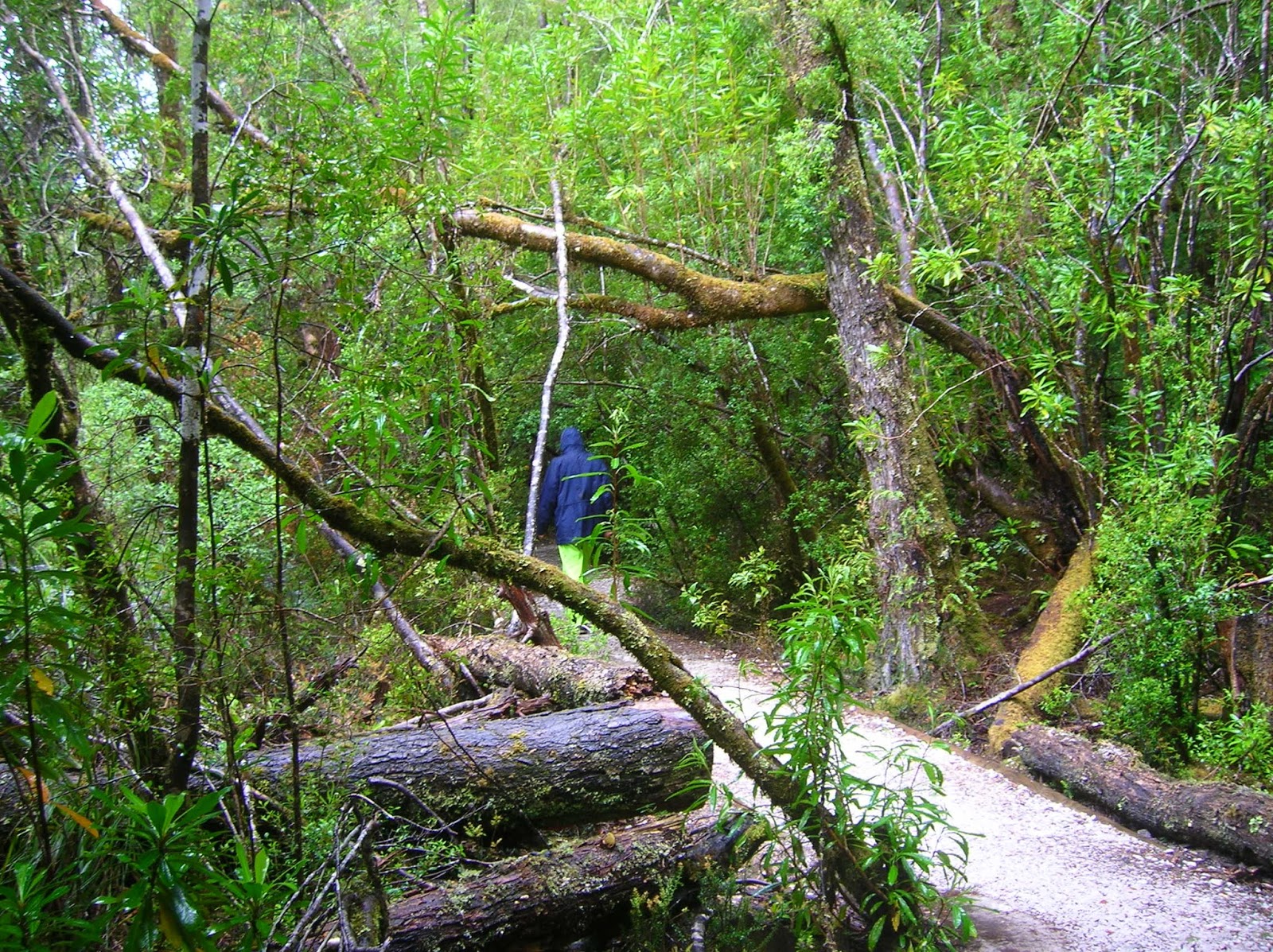
Wednesday 7 January 2009 – Darryl took off early for ‘The Walls of Jerusalem’ walk. I eventually got organised and followed up the track. This National Park is very hard to get any information about, but my plan was to walk for an hour and then walk back. 


It took me ¾ of an hour to get to the ‘Trappers Hut’ so I continued up onto the plateau. I came to a fork in the road, and knowing that Darryl had gone the other way, left a note telling him that I had taken the Lake Adelaide track. I was hoping to get some views, but after continuing on over the plains for another ½ an hour it became apparent that the track was not going near the edge (and it was so indistinctly marked I was reticent to venture off it), so I turned back. My walk took just over 3 hours in total, and Darryl arrived back at the campsite an hour later, and thinks he got as far as ‘The Wailing Wall’ (but we will have to wait until we return home to check it on Google Earth). The temperature dropped rapidly so we opted for an early retirement to bed.


Thursday 8 January 2009 – During the night the rain came in and it poured on and off. In the morning it was cold and wet so we took our time getting up. The rain eased enough for us to pack up, but after we had hit the road, the skies cleared and the sun came out. The first walk, on our way was Alum Cliffs. This was a gentle uphill walk, just past Mole Creek. The cliffs were certainly spectacular, and there was an adjacent red ochre cliff. Further east we passed a sign which said Lobster Falls. The was not mentioned in any information, and there was no indication of distance or time, but we turned back and drove in a short way before Darryl decided the road was too rough and parked the car. We walked in the rest of the way, and the whole walk took a little over an hour. The falls were quite lovely, and well worth the walk with the surrounding rock formations looking very interesting. A turn to the south took us to the Salmon and Ginkgo Farm where tastings were free, and based on that we purchased some 'hot-smoked' salmon for lunch, and a little tub of Rillette for later. We also bought some dried Ginseng. In Deloraine we had lunch at the 'Railway Park' which had a historic municipal hydro power station on the river. 

South of Deloraine is Liffey Falls, and we felt that there were one of the prettiest falls we have seen. There were 3 cascades, and 'shoot', and then the falls over tiers of rock. Some of the rocks also had marine fossils. The road was a bit scary, being quite windy and narrow. Darryl decided that he wanted to see 'The Great Lakes' so we headed up onto 'The Great Western Tiers'. Pine Lake walk was interesting, but being alpine was absolutely freezing cold! We drove pretty much around 'The Great Lake' and passed Lake Arthur. We had initially thought we might stay in a van park at Miena, but that area is nearly 1100m above sea level, and was freezing, so we drove down off the tiers to find a warmer spot for the night at Longford.
Friday 9 January 2009 – It as a beautiful morning, and we headed down the Midland Highway to Ross. This historic town was the site of a convict-built bridge with carvings of the faces of locals, as well as 'The Women's Prison'. We spent some time wandering around admiring the sandstone buildings, and looking at what as left of the prison (really only the Commandant's House which is now the museum).

 As the weather was so good, and we had the time, we then decided to go to Ben Lomond National Park (although this is in the North-East, on our way down, it had been cold and raining) – we could not have had a better day for it. 


The road up is famous for a section called 'Jacob's Ladder' which was truly scary – very narrow, steep, and windy. Luckily, we did not meet any other cars on the way. In the winter, this is a ski resort, and has chalets and chair-lifts, but was currently pretty-much abandoned. 


We found the walking track and made it to the highest peak 'Legges Tor' 1536m high. At last I can say I have made it to the top of one of the highest mountains in Tassie! We camped that night in the National Park, and although there were a few spits of rain, it was dry, but at 995m quite cold (although Darryl's fire certainly helped).

Saturday 10 January 2009 – Unfortunately, while packing up I hurt my back while putting Darryl's bike on the car. This put a bit of a limit on me, but as this was he last day in Tasmania, it was good to have an easy one. 

First port of call was Ashgrove Cheese Factory. This as in a lovely rural location just north of Elizabeth Town. We were able to try all their varieties, and we then bought some Double Gloucester and another lovely variety. I wanted to try and see the platypus at Latrobe so we went further north. As we were driving down the road to the reserve, Darryl said “that person is riding their bike just like Helen – oh – it IS Helen!” As we drove past I yelled at her for Queenslanders to get off the road, and we stopped and had a chat. Although we knew she was also in Tassie, her schedule and ours did not coincide, and I didn't think we would see her,  but unfortunately her other was suddenly taken ill and she was heading back to Melbourne at night (for an emergency flight back to Rocky). We arrived at the reserve, and Helen soon after, but did not see any platypus (possibly due to a couple of locals who turned up to swim their dogs). Just north of Latrobe is Anvers Chocolate factory, and I was determined to visit after missing Cadbury's in Hobart. We bought delicious dark and white chocolate and truffles, and I got a cup of Chilli Hot Chocolate....mmmmm! The caravan park in Devonport had an ensuite site, and this was quite a treat as it had a spa. This meant I as able to have soothing hot water on my sore back. The evening was really warm and pleasant.
  
Sunday 11 January 2009 – The ship started boarding an hour earlier than scheduled, and left late due to the large number of passengers. We had decided on a day return, and it didn't require a cabin. Sailing back to the mainland on Spirit of Tasmania was very smooth and calm. We passed the other Spirit around 2pm, and arrived back in Melbourne around 7pm. We wanted to get out of Melbourne as soon as possible, but weren’t quite sure where we were heading. We unsuccessfully tried a couple of National Parks..only to be confronted with locked gates. We also tried Kinglake National Park, and eventually, (at 10.30pm) found an old forestry road to set up on, and went straight to bed.

Monday 5 January 2009

Week of Monday 29 December 2008 - Cradle Mountain


Monday 29 December 2008 – We found a nice lookout at Rosny Park which gave us nice views of The Tasman Bridge and the Port, and after stocking up on supplies we drove to the historic town of Richmond, which has a Lake St Clair expecting to be able to go on a walk, but the rain started and all we could manage was a view of the lake and the fringing mountains. 


Thinking that we would return in the morning, if the weather was better, we then drove on little way to Lake King William to camp. What a contrast to the pretty Lake St Clair....the lake was a desolate beautiful stone bridge, a famous goal, and some lovely old buildings. As we were then going West, and didn't want to travel on roads we had been on before, we took some backroads, and part of the trip as unsealed. This particular valley was very dry. 


We arrived at the beautiful place of dead trees...but it was the only available camping ground. This was the first time that we have had to set up our camp in the rain, and it rained on and off all night.


Tuesday 30 December 2008 – As it was still raining, we decided that it was not worth returning to Lake St Clair, and proceeded west. All along this road here are lovely views of the mountains, and we stopped to take photos at several places. The rain was lighter when we arrived at Franklin River Nature Trail, so we walked through the rainforest to where the Franklin and Surprise Rivers meet. The sun had even come out by the time we stopped at the Frenchman's Cap Walking Track. This is the start of a 4-5 day walk (and judging by the number of cars in the carpark, it is very popular), but it is also possible just to walk down to the swinging bridge across the Franklin River, which we did. 
The ranger was doing some work along the track, and Darryl assisted him by carrying some wire back up to the carpark. Because of the rain overnight Nelson's Falls were in a torrid flow, and it was not possible to get too close as the water spray was very cold, but they were very beautiful. 


A sheltered shed at Lake Burbury was our chosen place for lunch, but the rain stopped anyway, so we were also able to get down to the shore, and admire the circling mountains. 


I think everyone finds it a shock the first time they see the bare desolate hills (stripped by years of copper mining), around Queenstown, but they had a strangely attractive quality. In the centre of town is Mine Siding which has interesting sculptures documenting the history of the town, and the lookout gave spectacular views of the town and the mining area.


 Due to the rain we decided not to venture onto any of the unsealed tracks to the south, and instead continued to Strahan. This township seems very commercialised, so we continued past down to Macquarie Heads, the entrance to Macquarie Harbour, and found a camping spot (which luckily was available due to the previous night's rain). There were a lot of people fishing, although there was a strong cold wind, and heavy showers at times. We chatted for some time to neighbouring campers, Neil and Rose, until Paul (a familiar-looking actor – Paul Bishop from Blue Heelers), started to interview Neil about his remarkable self designed and built portable 'woodstove'. That night we were bombarded with fierce wind gusts and squalls all night long, so we had a very disturbed sleep. Darryl also heard a Tasmanian Devil barking (confirmed by our neighbours in the morning).  


Wednesday 31 December 2008 – It was raining when we woke, so once again we had to pack up in the wet – luckily there was a lull while we folded up the tarpaulin, but it came pelting down again before we had finished putting away the ropes and poles. North of Macquarie Heads is the long Ocean Beach, and we took a side trip down for a look. There was pounding surf and some very discoloured water. Further north are the amazing Henty Dunes. It was a steep climb up the 30m dune,  but the view was amazing – dunes in all directions to the ocean and forestry, and it answered a question that Darryl had been pondering about some of the  'piles' of dirt in the forestry. A little further on was a lookout of the dunes, Ocean beach, and some mountains. 

Zeehan is a historic silver mining town, and just before reaching it we drove up to the abandoned smelters, which also offered great views of Mount Zeehan


 The other attraction to us was the Spray Tunnel, also a relic of the silver mining days, which is 100m long, 3m high and only 2.2m wide. Darryl drove through this one-way railway remnant very skillfully, but was pleased to get safely to the other end, where there was a shaft and other relics of the mine. 


Montezuma Falls, reputed to be one of the highest falls in Tassie, is just south-west of Rosebury. Along the road is the site of Williamsford, once a bustling mining town. The falls walk is usually a 3-hour walk, but as the track follows an old tramline, it is allowed to ride bikes, and we were really pleased that we opted for this, firstly as the trip then only took us 40 minutes each way, but also as there were many patches of sticky mud, which were much easier to ride through (although we did end up covered in mud whereas the walkers only had wet and muddy feet!) Most of the 'old' mining towns still have mining activities being undertaken in one form or another. It was the end of the day and we were, once again, looking for a suitable campsite for the night. We drove on and on searching for any place, when we chanced on an a mining ghost town – this place had every building removed, and all that was left was the roads and gutters, along with nice flat grassed yards, slowly being reclaimed by native vegetation – perfect! That night, though, we got more of the same as the previous night, strong winds (which blew down some of our setup) and very heavy rains. Still, it was a lovely location to spend New Year's Eve, but so cold we went to bed at 9.30pm.


Thursday 1 January 2009 – Once again we had to pack up in the rain, and it looked 'set-in' so we decided to head north. On the way we stopped at Hellyer Gorge. The drive through the road was lovely, but the walk at the picnic area was very disappointing – in fact we did the 15 min walk a second time thinking we had missed the turn or something! Arriving at Burnie we were able to get fuel and groceries, but were disappointed to find the Tourist Information closed (despite their sign saying open on public holidays). We had lunch at a nice riverside park at Somerset, before finding the Fossil Bluff at Wynyard. 
This was really amazing, with layers of fossils being constantly eroded away by the waters of the Bass Strait


West along the coast is the quaint historic town of Stanley, with convict ruins, and 'The Nut' a huge volcanic core sitting out into the ocean. There is a chair lift, but we were planning to walk up, but we beaten by the rain, and a lack of time to wait for a lull. Arthur River, on the West coast, is the end of the bitumen, and we then started on 120km of gravel road south through the Arthur Pieman conservation area. Due to the twist and turns, the condition of the gravel, and the rain, travel as only possible at about 65km per hour – the signs say the trip takes 2 ½ hours. It was very distressing to see the 1000's of hectares of burnt out forest, which was only just starting to reshoot (we later found out that the fire had been deliberately lit by someone lost around 9 months before, who was trying to attract attention). We eventually arrived at Corinna, and then drove a few km back to camp the night beside the Savage River. Once again we had strong winds and rain during the night.


Friday 2 January 2009 – The weather looked like it was clearing, and although all our gear was wet, the sun made an appearance as we had breakfast and packed. Back at Corinna we boarded “The Arcadia II” a Huon pine boat which took us down the Pieman River to the Heads, where we walked to the beach head into a freezing 'Roaring Forties' blast. 


There were quite a few beach shacks (now in National Park land), and lots of logs caught up in the sand. The cruise was quite informative, with lots of information given about the various trees, Huon Pine, Sassafras, Stringy Bark (also known as Tasmanian Oak), Myrtle and Laurel, as well as the history of the area and the boat. We passed a couple of waterfalls, and also saw some Sea Eagles – some flying, and the other pair sitting in trees. Back at Corinna, there is the 'Fatman Barge' to take vehicles across the river, but we had come from the north, and went back on a different northern track – which took us back to our 'ghost town' where we, camped again.


Saturday 3 January 2009 – We fuelled up at Waratah before getting to Cradle Mountain National Park around 10am. As it was the weekend, I was concerned about getting a site at the campground, and all that was available was an unpowered site, so we took it. The Visitor Centre is nearby and we walked to it. 
From here there is a free shuttle bus service to the start of the walks (we heard later that the carparks are so tight that there was a two hour wait to get your car up). We alighted at Ronny Creek carpark, and started our walk on the Cradle Valley Boardwalk, where we came on a wombat happily grazing just beside the track, oblivious to interest from passing photographers. Snow was visible on the high mountain peaks from here. At an intersection we left the boardwalk and started on the Overland Track which had some slushy bits. 


At on point the vegetation got denser and taller and we were treated to the delightful Crater Falls. Over the ridge was the amazing Crater Lake surrounded by high, dark mountains topped with snow. Although it is called Crater Lake because of the way it looks, it is actually a glacial lake, and is at 1035m high. Our walk took us around Wombat Peak to a ridge which gave us views of Crater Lake to one side, Lake Lilla and Dove Lake to the other side, and to Marion's Lookout (another 25 minutes of steep climbing) in the middle. 


We then descended to Wombat Pool, which was characteristically stained black from the surrounding Button Grass, around to Lake Lilla where we could then see Little Horn, and Weindorfers Tower, but the peak of Cradle Mountain was obscured by cloud. It as then a short walk back to Dove Lake carpark where we caught the shuttle bus back to camp. The camping ground had lovely kitchen facilities, with wood fire heating, which was really appreciated. There was no rain, and we even had some sun, although it was still quite cold 8oC when we had arrived in the morning.


Sunday 4 January 2009 – There wasn't a cloud in the sky – it was going to be a fantastic day at Cradle Mountain. It was an early start as Darryl planned to walk to the 1545m peak of the Mountain, so he caught the first bus up. My plans were more moderate, to walk the circuit of Dove Lake, so I was able to leave a bit later. It is advised to walk the circuit in a clockwise direction as it gives the best views, and this was certainly true. The first stop along the way was Glacier Rock. This is a huge upright boulder with many grooves across the grain of the rock, caused by the glacier forcing rocks across the face 10000 years ago. There were many King Billy Pines, Deciduous Beech, Scoparia, Pandani, and Tasmanian Waratah along the way, as well as lovely views of the peaks, waterfalls, and Dove Lake itself. Near the end of the circuit was the historic boatshed. The views of Cradle Mountain were spectacular, with intense blue sky behind, and the sides sprinkled with a little snow. I came back to Ronny's carpark to also look at Waldheim, the historic chalet and museum originally built by Weindorf, and went along the forest walk there, through huge King Billy Pines. Weindorf was instrumental in getting Cradle Mountain made into a National Park back in the early 20th Century. 
Darryl's walk had taken him over part of the same track we had covered the previous day, but he continued on from Wombat saddle up to Marion Lookout (passing small pockets of snow), to get spectacular views; and along the Overland Track, which had a fair snow cover. In parts the trail was very muddy, especially where the timbers were rotten, and it took considerable care for him to keep his precious K26s clean and dry! 


He passed the Kitchen Hut and the recently installed, but smelly toilet, 2 hours return from the summit. Just before here a lot of work had recently been done improving the boardwalk. 


At this point he first noticed other people behind him, and continued on to the summit, (slipping on the snow covered broken needles of dolerite), where he had fantastic 360o views. He was surprised to see plants still surviving under the snow. Luckily, after a few minutes, another walker arrived, so they were able to record their achievements for each other. On the way back there were at least another 15 walkers heading for the summit – many of them ill-prepared for any sudden weather changes (in fact at least 2 people were not even carrying any water!!!!) Unfortunately,  
Darryl had a couple of slips on ice on the way down and ended up with a wet tail. He took a longer track on his return from the summit, passing beneath the face of it, and also took a longer side route past Twisted Lakes and Hanson Lake (this turned out to be the worst part of the track – wet, muddy and slippery), and he was very relieved to see the sign indicating 45 minutes to the Dove Lake carpark (especially as he had started getting cramps). He did not get back to the camp until around 3pm, and said it was a pretty hard day, and was quite tired, but still managed to bake bread for me.